 comfyui_pcg
World tiles#
A 2 km x 2 km open-world terrain delivered as 4 x 4 tiles, engine-agnostic: tiled 16-bit height maps with shared edges, six material weight maps per tile, and per-tile instance tables for trees, bushes and rocks, plus a minimap and a preview.
Load it#
Drag example_workflows/pcg_prod_world_tiles.json onto the ComfyUI canvas and press Queue. Only comfyui_pcg nodes plus ComfyUI's Preview Image are used. Hydraulic erosion takes about a minute on numpy, ten-odd seconds with CUDA.
Deliverables#
All files go to output/pcg/world/.
| Files | Content |
|---|---|
height/Height_x{tx}_y{ty}.png | 1025 x 1025 samples, 2 m per cell, cut into 16 tiles of 257 x 257 as 16-bit PNG. Adjacent tiles share the row of pixels on their common edge, so heights at the seams are identical bit for bit. Metres = minimum + value x range; the range is range_scaled in Height.json, one range for the whole map. |
height/Height_full.r16 | The whole height map as raw 16-bit. |
weight/<Layer>_x{tx}_y{ty}.png | Six layers (Grass, ForestFloor, Sediment, Rock, Snow, Water), one 8-bit greyscale PNG per tile and layer. They sum to 1 at every pixel, ready for an engine's terrain layers. |
instances/Instances_x{tx}_y{ty}.csv | Trees (three pines and two broadleaf types, chosen by altitude), bushes and rocks, one CSV per 512 m tile, plus Instances_index.json listing the tiles. Rock names match the SM_Rock_0N assets of the rock assets pipeline. |
Overview.png | A lit minimap with the tile borders drawn in yellow. |
Coordinate convention (written into every .json): the origin is the north-west corner, which is the top-left of the height map; x points east, z points south (same as the image row order), y points up; units are metres. Instance transforms read the same way as in Copy to Points, so what the preview places is exactly what the tables say.
Step by step#
1. Terrain
- COP Noise (PCG) (1025 x 1025, simplex,
hybrid_terrain, 8 octaves) plus a COP Wrangle (PCG) that adds a large mountain band. Inside the band the relief is a ridged multifractal on domain-warped coordinates (crest lines where a noise crosses its middle value, each octave weighted by the one before), so the mountains have sharp crests and branching spurs instead of round cones. - COP HeightField Stream Power Erosion (PCG) cuts valleys, COP HeightField Thermal Erosion (PCG) makes talus, COP HeightField Hydraulic Erosion (PCG) adds gullies and alluvium, COP Flow Accumulation (PCG) finds rivers and lakes, COP HeightField Splat Map (PCG) splits five materials.
- COP Height to Normal (PCG) (strength 2048, world size 2050) gives the terrain normal used to tilt rocks.
2. Ecology
- A COP Wrangle (PCG) derives the forest: grassland below the tree line (normalized height 0.62), in noise patches. It splits the splat layers into the six weight layers, computes the three scatter densities (
d_tree,d_bush,d_rock), converts the terrain normal to world axes (tn) and paints a preview colour (lush and dry grass in patches, darker rock lower down). The colour is written linear, like any albedo; the mesh preview converts it back to a display colour forCd.
3. Scatter
- Three COP Layer To Points (PCG) nodes (mode
scatter) scatter 15,000 trees, 8,000 bushes and 2,500 rocks by their density layers, sampling the height (height_scale2048) and the attributeshnandtn. - One Wrangle (PCG) per type picks the asset name and the orientation: trees stand upright with a random rotation (pines higher up, broadleaf lower, mixed in between); bushes lean a little with the slope; rocks lean 70% towards the slope normal and are sunk by
0.25 * pscale. - Merge (PCG), Transform (PCG) (moves the origin to the north-west corner), and Blast (PCG) removes points that fell half a cell outside the terrain (they would create empty extra tiles). Export Instances (PCG) writes the CSVs in 512 m tiles.
4. Files and preview
- COP Write File (PCG) nodes write the tiled height (16-bit,
shared_edgeon,value_scale2048), the full.r16, and the six weight layers. - COP Light (PCG) plus a Wrangle that draws the tile borders produce the minimap, written as
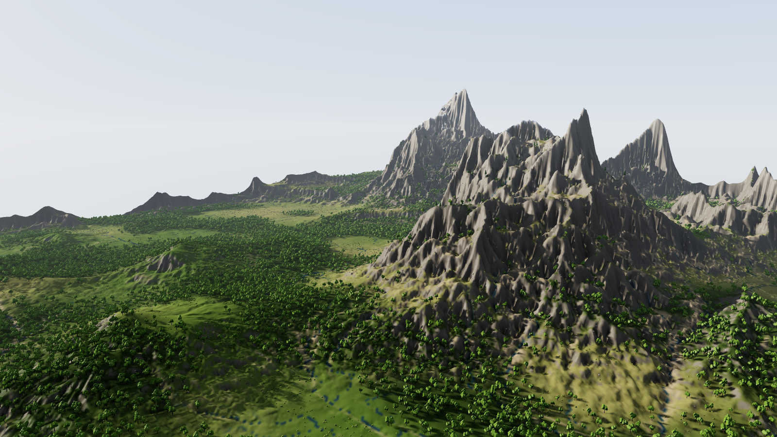
Overview.pngand previewed. - COP HeightField to Mesh (PCG) (every 2nd sample, about half a million triangles) builds the terrain mesh. Proxies stand in for the engine's assets: pines of three stacked cones (Tube (PCG)), broadleaf trees with a crown of five lumpy clusters, bushes and angular rocks (Sphere (PCG) plus Point Jitter (PCG)), chosen per point by a
kindattribute and placed with Copy to Points (PCG) (Piece Attribute). A Camera (PCG) over the south-west lowlands looks toward the mountain range, and Geometry Preview (PCG) renders it in the Outdoor look (low sun, haze, sky) at 1600 x 900.
Worth tweaking#
| Node | Parameter | Effect |
|---|---|---|
| COP Noise / mountain Wrangle | rand_seed, code | A different world. |
| Ecology Wrangle | code | Tree line (0.62), forest patch size, density formulas. |
| COP Layer to Points (x3) | count, rand_seed | Number of trees, bushes and rocks. |
| Tree / bush / rock Wrangles | code | Asset names (match your engine's assets), altitude split, tilt, scale range. |
| Write File / Export Instances | tiles_x, tiles_y, tile_size | Tile layout of the deliverables. |
See also#
- Terrain maps: the same terrain chain at a smaller scale.
- Rock assets pipeline: the rocks these tables reference.
- Viewing and export: writing images and instance tables.
- Example index.